
Image Source: Flickr
Keeping track of what’s exactly buried underground on a worksite can be a challenge, which is why utility locators follow the uniform color codes mandated by the American Public Works Association (APWA) for temporarily marking their facilities. The American Standards Institute (ANSI) established these colors as the American National Standard for Safety Colors. As a quick refresh, the APWA color code for utility marking is:
- Red: electric power lines, cables, conduit and lighting cables
- Orange: telecommunication, alarm or signal lines, cables or conduit
- Yellow: natural gas, oil, steam, petroleum or other flammable
- Green: sewers and drain lines
- Blue: potable drinking water
- Purple: reclaimed water, irrigation and slurry lines
- Pink: temporary survey markings, unknown/unidentified facilities
- White: proposed excavation limits or routes
These colors help identify unseen hazards that need to be taking into account during excavation, but the color system only warns construction workers of the type of hazard. Once the uniform color code went into place, other utility marking codes followed to appropriately identify underground conduits, cables, pipes, their facility owners, and descriptions of the facility.
This systemized notation system may look like a secret language until you start to decipher it. Luckily, the Common Ground Alliance (CGA) maintains a set of Guidelines for Operator Facility Field Delineation to indicate the infrastructural pathways of buried wires and pipelines.
For example, according to the guidelines, spray painted lines for marking a single facility can be done in two ways. The first is to place lines marking the center of the facility, as seen in the image below.
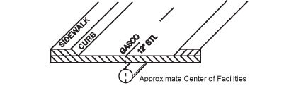
Image Source: CGA
The second is to mark the outside edges of the facility with a horizontal line drawn through the center to form an H-shape.
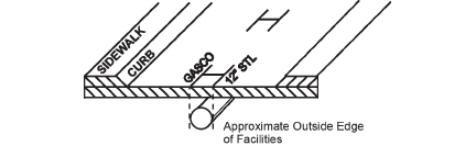
Image Source: CGA
Both of these images identify a gas pipeline using the appropriate abbreviation for the gas company name, GASCO. The pipe is marked as 12 inches in width, and the STL abbreviation indicates that the pipeline is constructed from steel.
Another common symbol is the diamond shape used to mark a conduit. Here you can see four 4-inch plastic conduits and the telecommunications company owner.
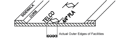
Image Source: CGA
If you’d like to learn more about abbreviations, the CGA has specific guidelines for those, too. The company name identifier must always appear at the top or to the left in the abbreviation order, followed by appropriate construction descriptions, and end with the infrastructure material.
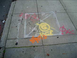
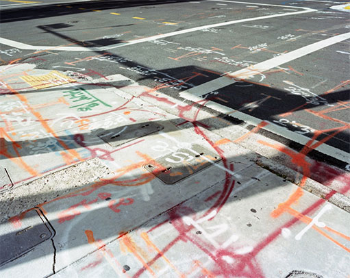
Image: Flickr
When there is “no conflict” between buried utilities and the proposed area of excavation, locators will mark “NO” oftentimes followed by the name of the facility, or the abbreviated facility type with a line drawn through it. The image above shows both: “G” for gas with a line slashed through it—indicating no conflict with gas facilities—and an orange “NO” is followed by the telecommunications company and a “D” meaning “no distribution.”
Mapping and marking the underground infrastructure is a complex task, and these intricate symbols provide a brief window into these important and intricate systems. Next time you come across some cryptic street scribbles, you’ll know that these annotations are an important element of damage prevention and greater public safety.